Modern advanced technologies are being intensively introduced into the practice of agricultural production. To read more about the main trends of precision farming technologies, cloud services for managing an agricultural enterprise, systems for field monitoring, and complex farm management, visit this website.
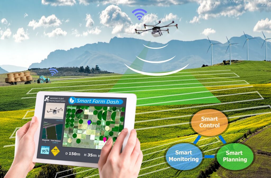
Among today’s farming technologies, an important place in providing information is played by remote sensing: satellite imagery and imagery made by unmanned aerial vehicles. Such information is a priori reliable and reflects the actual picture of the state of an agricultural site, primarily thanks to NDVI calculation.
Ultimately, space-enabled agricultural tech supports farmers in staying productive and sustainable at the same time. Let’s see how this works.
Satellite Monitoring and Precision Farming
Precision farming implies the use of such tech as GPS, robots, drones, and sensors with the goal of increasing efficiency of agricultural practices. And an efficient farm is naturally more sustainable. Higher precision in farming practices means less energy, labor, and products required for production. Hence, the farmers save time and money while still harvesting the same or even higher yields.
Here is the main three satellites-performed functions that are most useful for farmers:
- Mapping. This allows for estimating the size of land used for different types of agriculture;
- Measuring. Analyzed satellite data available via different farming software can provide measurements on a range of properties, including crop and soil health, yield, plant growth stage, and much more;
- Monitoring. Comparing satellite pictures for a period of time, farmers can see how the land has changed and what are the patterns of its development. This allows for planning smart crop rotation and field treatment activities based on the land’s characteristics.
Now, here is what possibilities these functions open.
Inventory, Accounting, and Land Stewardship
Apart from allowing for determining the actual land size, satellite imagery also enables identification of unused areas or areas inappropriate for agricultural purposes. With the help of satellite images, farmers can detect erosion, waterlogging, and other manifestations of land degradation. This analysis helps to plan agricultural work wisely.
Crops Monitoring
Regular satellite imagery helps to make a qualitative assessment of the germination and ripening of crops, and to identify diseases at an early stage. Based on the results of remote sensing data processing, maps of the inhomogeneity of the state of crops can be created, as well as recommendations for the differentiated application of mineral and organic fertilizers.
Machinery Management
Satellites help farmers monitor not only the harvest but also evaluate the effectiveness of vehicles performing field activities. Tractors, combines, and other machines can be equipped with GPS devices, which allows for tracking their time of work, the area of field they covered, the amount of the harvested crop, etc.
Not all opportunities for working with satellite data are equally in demand and used by the farmer. Thus, identification of crops by the reflective spectrum is more in demand by departmental structures and is just starting to find use among farmers for competitive intelligence and comparative analysis of their own crops with similar crops in the region.
The measurement of surface qualities is associated with the use of vegetation indices. This direction of using images is the most common, since it significantly exceeds the capabilities of field scouting, providing information about the state of crops from all fields of the farm at once.
Surface monitoring records the dynamics of changes in the state of crops during the growing season. Crop activity, change in state after irrigation, fertilization or plant protection products allow farmers to conclude about the effectiveness of taken activities. Frequently updated images enable the monitoring of field work effectiveness – sowing, irrigation, fertilization, harvesting, etc.
Satellites are already helping farmers assess the data on the state of their crops and monitor the dynamics of its change better and faster. This technology has already proven its value and economic benefits by reducing crop losses from lack of nutrition or protection and more efficient use of expensive agrochemicals. This is mostly due to the possibility of applying the VRA approach for smarter use of resources.
Space Farming to Facilitate Terrenial Agriculture
Space transforms modern farming not only with satellite data based software solutions but also by inspiring other technologies and practices. For instance, astronauts and polar explorers are already growing food in space and Antarctica. So, why not encourage terrestrial communities to get into the greenhouse game.
Today, several key trends have emerged in the world that determine the approach to growing vegetables and greens. One of the most advanced growing methods, gaining more and more popularity, is a low-volume technology, when plants are grown not in the ground, but in special containers filled with a substrate in which favorable conditions for their growth are created. Cultivation of crops can be carried out on peat substrates, on mineral wool or aeroponics. In this case, the used consumables affect the cost of the product.
In general, the global trend is to understand the fact that it is impossible to produce high-quality products on traditional soil due to pests accumulation. It is possible to create a favorable controlled environment for plants only when there is a total “cleaning” of the site every year.
There is also a growing interest of farmers in growing products using the biological method, which is a positive factor in the field of greenhouse vegetable growing. The main principle of the biological method is to avoid using pesticides for pest control and to use exclusively biological plant protection products, as well as organic growth regulators.
In addition, a promising direction of greenhouse crop growing is the technology of photoculture, that is, growing plants in the off-season due to additional electric lighting (supplementary lighting). This compensates for the lack of natural heat and light, which is lacking in a number of northern regions.
The required electricity costs are determined by the geographical latitude of the greenhouse’ location, the season, the early ripening of the crop or variety, and the technology used.
Ultimately, space tech keeps proving to be a huge driving force propelling the agricultural industry. Be it satellite monitoring or inspiration for new ways of growing crops, space is an unmatched source of possibilities for ensuring sustainability in farming practices.


